
At least 30 high-resolution satellite pictures have emerged from Galwan Valley in Eastern Ladakh, which indicates all is not well at Galwan Valley yet. Both Indian and Chinese troops have apparently taken up new positions in the Galwan Valley, fresh satellite images show.
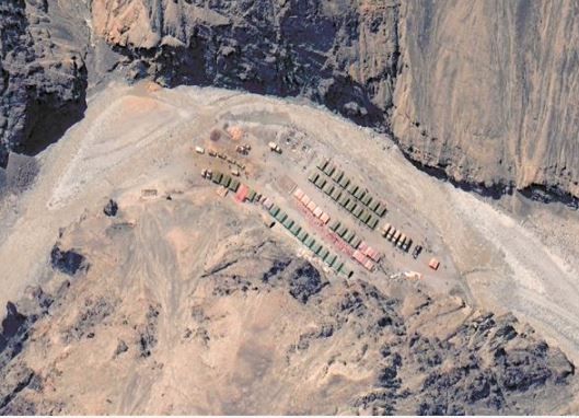
China has reportedly added new structures near the site of a deadly border clash with India. Images taken by the US-based Maxar Technologies show what appear to be Chinese structures on a terrace overlooking the Galwan River, close to where Indian and Chinese military engaged in hand-to-hand combat for hours last week, resulting in the death of 20 Indian soldiers.
China has not released its casualties from the confrontation June 15.

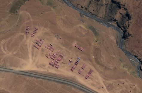
Satellite pictures of ground zero of the June 15 skirmish between Indian and Chinese troops show aggressive posturing by People’s Liberation Army troops near the Line of Actual Control (LAC).
Images captured June 22 — the day of Corps Commander-level talks in Ladakh — show a new forward build-up by the Chinese near Patrol Point 14.
On ground, the Indian side has also built temporary fortifications on the other side of the river as captured in the images.
The Chinese foreign ministry has issued statements laying claim to the entire Galwan Valley, a stand rejected outright by New Delhi. “The position with regard to the Galwan Valley area has been historically clear.
Attempts by the Chinese side to now advance exaggerated and untenable claims with regard to the LAC there are not acceptable,” a spokesperson from the ministry of external affairs said last week.
Indian and Chinese military commanders held their second round of talks Monday, which went for almost 11 hours. Both sides have reached a mutual consensus to disengage but the process of disengagement is yet to be finalised.
PNN