
New Delhi: Cyclone Biparjoy has started making landfall near Jakhau Port in Gujarat’s Kutch district after churning across the Arabian Sea for over 10 days, the India Meteorological Department (IMD) said Thursday evening.
Strong winds and heavy rains battered Kutch and Saurashtra coasts as agencies remain on high alert.
The landfall near Jakhau Port is the only recorded incident till now but, the process is expected to continue in coastal areas till midnight according to the reports.
“Dense convective clouds have entered Kutch and Devbhumi Dwarka districts and therefore, the landfall process has commenced. It will continue until midnight,” IMD Director General Mrutyunjay Mohapatra said.
The eye of the cyclone is around 50 km in diametre. Biparjoy is marching ahead with a speed of 13-14 kmph. Thus, it will take around five hours for the wall cloud and the eye to completely cross into the land, he said.
Authorities have evacuated around one lakh people living in vulnerable areas following a prompt warning from the IMD about the “extensive damaging potential” of the cyclone.
Officials said 15 NDRF teams, 12 teams of the State Disaster Response Force and personnel of the Indian Army, Navy, Air Force, Indian Coast Guard, and Border Security Force have been deployed for relief and rescue operations.
The Met office had earlier warned of very heavy (11.5 cm to 20.4 cm) to extremely heavy rainfall (over 20.5 cm) in Kutch, Devbhumi Dwarka, Jamnagar, Porbandar, Rajkot, Morbi, and Junagarh districts.
“We won’t be surprised if some areas record more than 25 cm of rainfall. Usually, they do not receive such intense precipitation at this time of the year. Therefore, there is a risk of flooding in the low-lying areas,” Mohapatra had cautioned.
Meteorologists had warned of extensive damage to standing crops, houses, roads, electricity and communication poles, and flooding of escape routes.
Hugh tides could inundate low-lying areas of Saurashtra and Kutch coasts, they said.
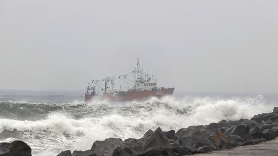
Several parts of coastal Gujarat have been recording heavy rains and high-speed winds since Wednesday.
Sea conditions are phenomenal (waves could be 10 to 14 metres high) in the northeast and the adjoining east-central Arabian Sea and all activities, including oil exploration, ship movement and fishing, have been suspended.
In 2021, cyclone Tauktae hit the southern coast of Gujarat May 17 when India was battling a fierce second wave of COVID-19.
According to the US Joint Typhoon Warning Center, Tauktae packed maximum sustained winds of up to 185 kmph, making it the “strongest tropical cyclone” in at least two decades to impact the west coast of India.
Biparjoy, the first cyclone in the Arabian Sea this year, rapidly underwent rapid intensification on June 6 and June 7, escalating from just a cyclonic circulation to a very severe cyclonic storm in just 48 hours, defying earlier predictions.
It has also sustained its strength for a longer-than-normal duration, which meteorologists attribute to due to an unusually warm Arabian Sea.
The IMD data shows Biparjoy has become the cyclone with the longest lifespan in the Arabian Sea.
The life period of Biparjoy, which developed over the southeast Arabian Sea at 5.30 am June 6, is about 10 days and 12 hours so far.
The extremely severe Cyclone Kyarr of 2019 over the Arabian Sea had a life of 9 days and 15 hours. It developed over the east-central Arabian Sea, had multiple recurvatures and weakened over the southwest Arabian Sea.
The very severe cyclonic storm Gaja of 2018 over the southeast Bay of Bengal had a life span of 9 days and 15 hours. It crossed the southern peninsular region, emerged into the Arabian Sea and weakened there, the IMD said.
Scientists say cyclonic storms in the Bay of Bengal and the Arabian Sea have been intensifying rapidly and retaining their intensity for a longer duration due to climate change.
PTI