New Delhi: ISRO will launch Earth observation satellite NISAR Wednesday. Developed with NASA, the satellite aims to improve the management of natural resources and hazards.
The observations of the NASA-ISRO Synthetic Aperture Radar (NISAR) satellite will be available to policymakers across the world, which will help frame better responses to deal with the challenges of climate change.


The USD 1.5 billion dollar satellite is set to be launched by the GSLV Mk-II rocket from ISRO’s spaceport at Sriharikota at 5:40 pm on Wednesday.
“NISAR is not just a satellite; it is India’s scientific handshake with the world,” Science and Technology Minister Jitendra Singh said in a statement here.
Singh said this mission lives up to Prime Minister Narendra Modi’s vision of India becoming a ‘Vishwa Bandhu’ – a global partner that contributes to the collective good of humanity.
As the first joint Earth observation mission between ISRO and NASA, the event marks a defining moment in the journey of Indo-US space cooperation as also in ISRO’s overall international collaborations, he said.
“NISAR will not only serve India and the United States but will also provide critical data for countries around the world, especially in areas like disaster management, agriculture, and climate monitoring,” Singh said.
A key feature of the mission is that all data generated by NISAR will be made freely accessible within one to two days of observation, and in near real-time in case of emergencies, Singh said.
This democratisation of data is expected to support global scientific research and decision-making, especially for developing countries that may not have access to similar capabilities.
The NISAR mission combines the technological expertise of both agencies.
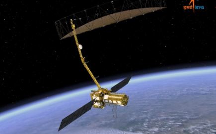
NASA has contributed the L-Band Synthetic Aperture Radar (SAR), a high-rate telecommunication subsystem, GPS receivers, and a deployable 12-meter unfurlable antenna.
ISRO, on its part, has provided the S-Band SAR payload, the spacecraft bus to accommodate both payloads, the GSLV-F16 launch vehicle, and all associated launch services.
The satellite weighs 2,392 kg and will be placed in a sun-synchronous orbit, offering repeat imaging of the entire Earth’s land and ice surfaces every 12 days.
“It will allow continuous monitoring of ecosystem disturbances and help assess natural hazards such as earthquakes, tsunamis, volcanic eruptions, and landslides,” the minister said.
The satellite will be able to track even subtle changes in the Earth’s crust and surface movement.
The data from the satellite will also be used for sea ice classification, ship detection, shoreline monitoring, storm tracking, crop mapping, and changes in soil moisture -? all of which are vital for governments, researchers, and disaster management agencies, Singh said.
PTI


