
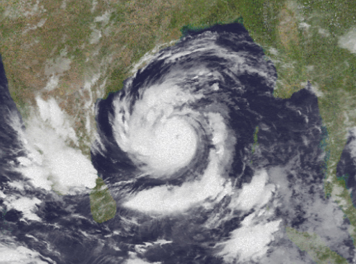
Bhubaneswar: The India Meteorological Department Monday said extremely severe cyclonic storm “Amphan” over the west and central parts of Bay of Bengal has intensified into a “super cyclone” with wind speed up to 240 km per hour.
The super cyclone currently lay centred at about 730 km south of Paradip, 890 km south-southwest of West Bengal’s Digha and 1,010 km south-southwest of Bangladesh’s Khepupara.
It is very likely to move northwards for some more time and then north-northeastwards across northwest Bay of Bengal and cross West Bengal-Bangladesh coasts between Digha in West Bengal and Hatiya islands in Bangladesh close to Sundarbans in the evening of May 20. According to sources, this is first time that super cyclones have been recorded in two consecutive years, Kyarr in 2019 and Amphan this year. For Odisha, this is the second super cyclone after the 1999 super cyclone.
Director General of IMD said the super cyclone may make landfall near Sundarban in West Bengal coast. The IMD has issued orange and red alerts for coastal Odisha, where damage is expected. Bhubaneswar Meteorological Centre director HR Biswas said most of the coastal districts will experience heavy rainfall activity from tonight and it will gradually increase and continue till May 20.
Under the impact of Amphan, heavy to very heavy rainfall will occur at a few places over the districts of Balasore, Bhadrak, Jajpur, Jagatsinghpur, Kendrapara and Mayurbhanj and isolated heavy rainfall is likely over Cuttack, Khurda and Puri districts, Tuesday.
There is possibility of heavy rainfall in Kendrapara, Jajpur, Bhadrak, Balasore, Keonjhar and Mayurbhanj districts May 20.
Apart from rain, the wind speed will gradually increase becoming a gale with wind speed reaching 75 to 85 kmph gusting to 95 kmph from May 20th morning along and off north Odisha coast (Jagatsinghpur, Kendrapara, Bhadrak, Balasore) and Mayurbhanj districts. It will gradually increase thereafter becoming 110 to 120 kmph gusting to 135 kmph along & off the above mentioned districts of North Odisha, Biswas said.
The weather agency said there could be extensive damage to kutcha and old or damaged pucca constructions, uprooting of communications and power transmission poles, disruption of rail and road links, crops and plantations is expected. Large boats, ships can also get torn from moorings.
Official sources in the SRC said, 600 cyclone shelters and 7,092 other permanent buildings with cumulative capacity to accommodate nearly 12 lakh people, maintaining social distancing norms, have been identified in 12 coastal districts.
Collectors of Balasore, Bhadrak, Kendrapara and Jagatsinghpur districts have been instructed to take immediate steps to evacuate all people living in thatched, asbestos, tile or any other sloped roof houses, huts or in low-lying areas in the areas likely to be affected.