
Bhubaneswar: The regional centre of IMD in Bhubaneswar Saturday issued an Orange Warning for several districts of Odisha.
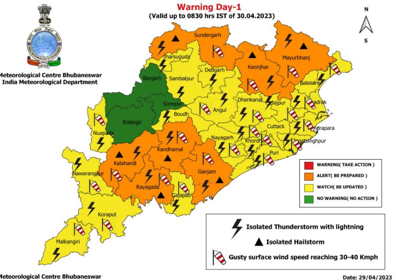
Upto 8.30 AM of April 30: As per the Orange Warning (be prepared), thunderstorm with lightning, hail and gusty surface wind speed reaching 30-40 kmph are very likely to occur at one or two places over Mayurbhanj, Keonjhar, Sundargarh, Rayagada, Kandhamal, Kalahandi and Ganjam districts, IMD bulletin stated.
Impact & action suggested:
- People are advised to keep watch on weather and take safe shelter during thunderstorm to protect themselves from lightning and follow traffic advisories in urban areas.
- Harvesting of Rabi crops may be regulated judiciously.
As per the Yellow Warning (be updated), thunderstorm with lightning and gusty surface wind speed reaching 30-40 kmph are very likely to occur at one or two places over Angul, Dhenkanal, Koraput, Malkangiri, Nabarangpur, Nuapada, Balasore, Bhadrak, Jajpur, Kendrapara, Cuttack, Jagatsinghpur, Puri, Khurda, Nayagarh and Gajapati districts.
Besides that, thunderstorm with lightning is very likely to occur at one or two places over Deogarh, Sambalpur, Jharsuguda and Boudh districts.
In the same timeframe, light to moderate rain or thunderstorm is very likely to occur at a few places over the districts of interior Odisha and at one or two places over the districts of coastal Odisha.
From 8.30 AM of April 30 to 8.30 AM of May 1: As per the Orange Warning (be prepared), thunderstorm with lightning, hail and gusty surface wind speed reaching 40-50 kmph are very likely to occur at one or two places over Mayurbhanj, Keonjhar, Sundargarh, Jharsuguda, Sambalpur and Bolangir districts.
Apart from that, heavy rainfall is very likely to occur at one or two places over Nabarangpur, Nuapada, Bargarh, Jharsuguda, Sundargarh and Kalahandi districts.
Impact & action suggested:
- People are advised to keep watch on weather and take safe shelter during thunderstorm activity to protect themselves from lightning and follow traffic advisories in urban areas.
- Harvesting of Rabi crops may be regulated judiciously.
As per the Yellow Warning (be updated), thunderstorm with lightning and gusty surface wind speed reaching 30-40 kmph are very likely to occur at one or two places over Kandhamal, Sonepur, Boudh, Angul, Dhenkanal, Rayagada, Koraput, Malkangiri, Cuttack, Jajpur, Bhadrak, Balasore and Deogarh districts.
In the same time frame, light to moderate rain or thunderstorm is very likely to occur at many places over the districts of interior Odisha and at a few places over the districts of coastal Odisha.
The weather agency forecasted no large change in maximum temperature (day temperature) over the next four to five days.
In Bhubaneswar, for the next 24 hours, a partly cloudy sky with one or two spells of rain or thundershower is predicted by IMD. Maximum and minimum temperatures are very likely to be around 39 degree Celsius and 23 degree Celsius respectively.
In the last 24 hours, the highest maximum temperature of 38.8 degree Celsius was recorded at Sonepur while the lowest minimum temperature of 21.8 degree Celsius was recorded at Nabarangpur, the bulletin informed.
PNN