
Bhubaneswar: Cyclone ‘Fani’ over the southeast Bay of Bengal is likely to intensify further into an extremely severe cyclonic storm during the next 36 hours, India Meteorological Department (IMD) said Tuesday morning.
By the evening of May 1, it is very likely to move north-westwards and thereafter recurve north-northeastwards towards Odisha coast.
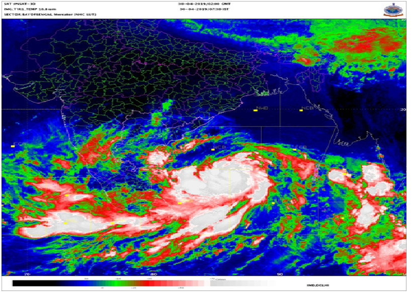
The system is now laid centered about 670km east-northeast of Trincomalee (Sri Lanka), 690km east-southeast of Chennai (Tamil Nadu) and 760km southeast of Machilipatanam (Andhra Pradesh), sources at regional center of IMD informed.
They further added that most likely exact landfall location can only be identified late in the day Tuesday.
Meanwhile precautionary measures are being put in place at war footing.
The Union Government has put the Indian Navy and National Disaster Response Force (NDRF) on alert. Further, the National Crisis Management Committee (NCMC) of Ministry of Home Affairs has issued Rs 340.875crore to State Disaster Relief Fund (SDRF) to assist them in undertaking preventive and relief measures.
The state government is also leaving no stones unturned. High level meetings led by the Chief Minister and the Chief Secretary were held Monday. The collectors of the coastal districts are being kept in loop. Leaves of officials on coastal districts have been cancelled and emergency evacuation, relief and rescue plans are being put in place.
It may be mentioned here that such a severe cyclone heading towards the state in the month of May is happening after 30 years. Last cyclone Odisha witnessed in the month of May was in 1989. Prior to this cyclones visited the state in this month back in 1897, 1914, 1917, 1982.
In general, Odisha witnesses cyclones season between July and October. Weathermen have pointed to changes in the global climate for this new development.
Fani is feared to have an effect not only on the coastal regions but also on the interior parts of the State.
IMD predicted that Koraput, Malkangiri, Keonjhar, Angul, Dhenkanal are some of the districts that are likely to be affected by it. The possibility of the cyclone causing harm to green gram, horse gram and vegetable crops in these parts of the state is high.
It is likely to bring winds reaching 40-50 kmph gusting to 60 kmph off Odisha coast from May 2 and likely to become 60-70 kmph gusting to 85 kmph from May 3 onwards. During these days, sea conditions are very likely to be very rough. Fishermen have been warned against venturing into the deep sea.