Kendrapara: Despite a comprehensive administrative survey conducted in April 2022, vast stretches of coastal embankments under the Aul division in Kendrapara district remain dangerously vulnerable.
As a result, tidal water from the sea continues to inundate farmlands and residential areas, displacing people and disrupting essential services such as transport, education, and healthcare.


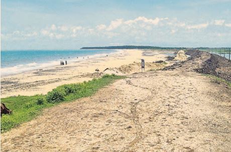
The Embankment Division, established in the aftermath of multiple natural calamities such as floods, cyclones, and the 2004 tsunami, was mandated to safeguard 744.47 kilometres of coastline spanning Aul, Rajkanika, Rajnagar, and Mahakalapara blocks.
Also Read: Odisha: Ex-headmaster sentenced to three-year RI for govt fund misuse
The 2022–23 fiscal survey report, signed by local officials — from Block Development Officers and Tehsildars up to the District Collector — had identified the vulnerabilities of the embankments. Yet, communities from Talachua in Rajnagar block to Batiaghara in Mahakalapara continue to suffer the brunt of unchecked tidal intrusion.
Villagers allege that tidal water is encroaching farmlands and villages by breaching multiple protective ring embankments. The most affected areas include Jambu Luna Gheri and Batiaghara Gheri in Mahakalapara sub-division and Gajaria, Utikana Luna Gheri, Keradagada, Padani Padmanabhapur, Gopalpur, Rajgarh, Gadadharapur, and Baragan in Rajnagar sub-division.
Of particular concern are the Geo Tube embankments in Pentha, which are at risk of collapse due to strong tidal currents. In some areas, the sea is just a few hundred metres away from vulnerable embankments.
River embankments along the Brahmani, Kharasrota, Gobari, and Hansua rivers are also becoming unsafe due to rising tidal impact, the villagers claim. During the last full moon, the tidal water overflowed into the Pattasala river, inundating Rangani’s Pattaparia and Bhekta mouzas in Rajnagar block.
Similarly, in Suniti panchayat of Mahakalapara block, tidal water entered fields and even homes in nearby villages through the Panchagochia pathway. In Batiaghara, sea water from the Bay of Bengal frequently floods localities such as Badatubi, Sanatubi, and Akhadasali near the Mahanadi river mouth, indicating the complete absence of effective embankments.
Residents in many of these areas lack even basic infrastructure due to the repeated waterlogging and neglect. Local environmentalists, intellectuals, and residents — including Basant Kumar Hati of Rajnagar, Subhasis Sadhangi of Rajkanika, Sunil Kumar Gantayat of Mahakalapara, Hemanta Kumar Rout, and Radhakanta Mohanty — have alleged that for the past two decades, project funds meant for embankment strengthening have been misappropriated by contractors and administrative officials.
According to official data, the Aul subdivision oversees 111.53 km of embankment, Mahakalapara 237.62 km, Rajnagar 302.12 km, and Rajkanika 93.20 km. Yet, the reality on the ground reveals that significant stretches remain either incomplete or poorly maintained.
Also Read: Odisha school teacher held for ‘molesting’ girl students
Executive Engineer Sambit Sahu of the division attributed the situation to the consequences of global warming, claiming that many embankments now stand just 1 metre above sea level. He said projects are underway to raise the height of these embankments to between 4 and 6 metres.
Still, affected villagers say little has changed on the ground and demand immediate, transparent, and accountable action before the next major tidal surge or cyclone brings greater devastation.
PNN


